| Map Image |
Map Title |
Description |
Created by |
Date Created |
Map Session |
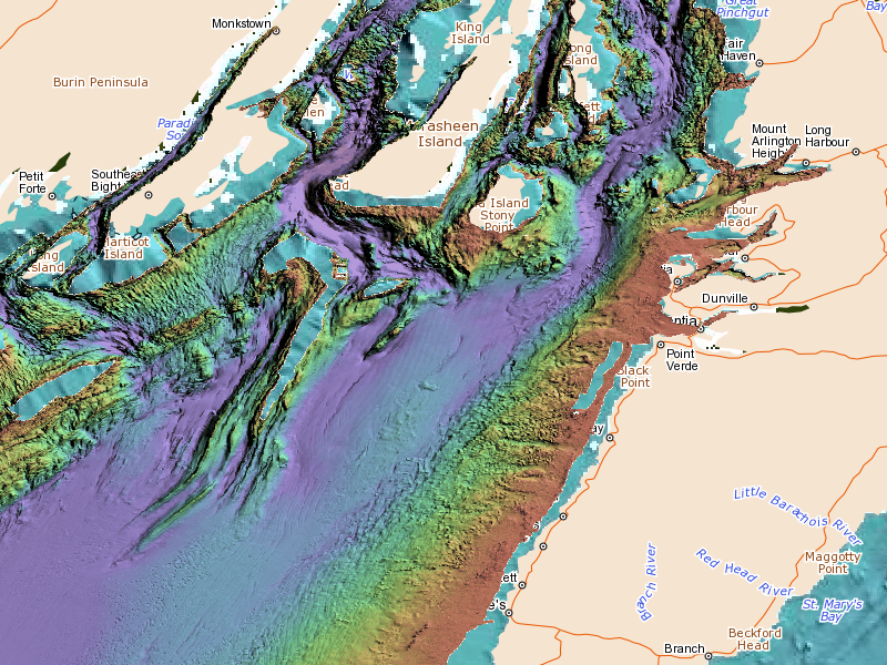
 | GEBCO bathymetry with OBIS Canada WMS | | Jeff McKenna | 2022-03-02 | mapset=95 |
 | مساج فلبينى أجمل مساج في جدة خدمات منزل فندق | https://business.google.com/u/3/dashboard/l/01899795221361832144?hl=ar | https://business.google.com/u/3/edit/l/01899795221361832144?hl=ar | 2021-02-13 | mapset=94 |
 | MH370 Phase 2 data | 5m resolution tiles from Phase 2 marine surveys conducted by the Governments of Australia, Malaysia and the People's Republic of China for the search for Malaysian Airlines flight MH370 in the Indian Ocean. | Jeff McKenna | 2021-01-25 | mapset=93 |
 | Dredge spoil sites | | Andy Sherin | 2019-11-04 | mapset=91 |
 | Nova Scotia (NS) Marine Plants | | Robert M. (Bob) Branton | 2019-08-26 | mapset=71 |
 | Sydney Harbour Case Study | Custom View of the Sydney Harbour Case Study | COINAtlantic | 2019-07-29 | mapset=sydney_harbour |
 | Atlantic Canada's Marine Species Distribution | Custom View of Atlantic Canada's Marine Species Distribution | COINAtlantic | 2019-07-29 | mapset=acmsd2015 |
 | Petroleum Vulnerability Project (East) | Custom View of the Petroleum Vulnerability Project: East View | COINAtlantic | 2019-07-29 | mapset=petroeast |
 | Petroleum Vulnerability Project (West) | Custom View of the Petroleum Vulnerability Project: West View | COINAtlantic | 2019-07-29 | mapset=petrowest |
 | Newfoundland Coastal Character and Indices | Custom View of the Newfoundland Coastal Character and Indices | COINAtlantic | 2019-07-29 | mapset=nl |
 | Bay of Fundy | Custom View of the Bay of Fundy | COINAtlantic | 2019-07-29 | mapset=bayoffundy |
 | Climate Stations | Climate stations served through Environment Canada's Geomet-climate WMS service | Jeff McKenna | 2019-02-06 | |
 | GeoMet-beta WMS Service | Testing Environment Canada's GeoMet-beta WMS service; displaying Ocean currents and surface/soil temperatures (WMS service: http://geo.weather.gc.ca/geomet-beta/?lang=en | Jeff McKenna | 2018-03-09 | |
 | Canvec WMS testing | | Jeff McKenna | 2018-02-14 | |
 | Area of Canada with the most radical change in snow fall | Mount Fidelity, Glacier National Park in British Columbia has the most snow fall average per year with a maximum of 1388 centimetres.
Victoria, British Columbia has the least amount of snowfall per year with a maximum of 13.8 centimetres.
All information was collected from www.CurrentResults.com and are an average of results from 1981 to 2010. | Wyatt Noel | 2018-02-05 | |
 | OBIS Canada IPT Species Distribution | http://coinatlantic.tools/csu/?mapset=acmsd2015
WMS:
http://coinatlantic.tools/cgi-bin/iptobiscanada | Paul Boudreau | 2017-12-13 | |
 | Newfoundland Coastal Character and Indices | http://coinatlantic.tools/csu/?mapset=nl
WMS:
http://dnrmaps.gov.nl.ca/arcgis/services/Coastal/Coastal_Character/MapServer/WmsServer | Paul Boudreau | 2017-12-13 | |
 | Petroleum Vulnerability Project | http://coinatlantic.tools/csu/?mapset=petrowest
WMS: http://coinatlantic.tools/cgi-bin/petromap? | Paul Boudreau | 2017-12-13 | |
 | Petroleum Vulnerability Project | http://coinatlantic.tools/csu/?mapset=petroeast
WMS: http://coinatlantic.tools/cgi-bin/petromap? | Paul Boudreau | 2017-12-13 | |
 | Sydney Harbour Case Study | http://coinatlantic.tools/csu/?mapset=sydney_harbour
WMS:
http://coinatlantic.tools/cgi-bin/sydneyharbour-diver2009? | Paul Boudreau | 2017-12-13 | |
 | Potential sources of contaminants | | AGS | 2017-08-17 | |
 | Atlantic Canada real-time Sea Surface Temperature | GIOPS Sea Surface Temperature for July 19, 2017 | Paul Boudreau | 2017-07-20 | |
 | Sydney Harbour Case Study Test | testing | Jeff McKenna | 2017-06-12 | |
 | Sydney Harbour Case Study | leveraging GeoNova 1:10k WMS service | Jeff McKenna | 2017-05-29 | |
 | test | | Andy | 2017-05-11 | |
 | Ocean Currents and Current Weather Alerts from Environment Canada's GeoMet WMS Service | As a large snow storm approaches the East Coast, red indicates a weather warning for the area. | Jeff McKenna | 2017-02-09 | |
 | Saint John Harbour coastal areas | Saint John and Musquash areas | Paul Boudreau | 2016-01-21 | |
 | Hainan | South China Sea | Paul Boudreau | 2016-01-13 | |
 | WMS Ifremer Bathymetry | maintained by Ifremer WMS Ifremer postal Technopole Pointe du Diable PLOUZANE 29280 FRANCE sextant@ifremer.fr | Jeff McKenna | 2014-10-10 | |
 | Multibeam Bathymetry Data | from Seafloor Mapping Lab | Jeff McKenna | 2014-10-10 | |
 | St. Marys River | | Jeff McKenna | 2014-10-09 | |
 | nl demo sept 2013 | demo | andy Sherin | 2013-09-11 | |
 | Placentia Bay bathy | | A Sherin | 2013-09-10 | |
 | Halifax Harbour Multibeam Bathymetry | Source: Canadian Marine Multibeam Bathymetric Data Web Map Service (WMS) | Jeff McKenna | 2013-05-13 | |
 | St. Margaret's bay Water Exchange | | Jeff McKenna | 2013-05-09 | |
 | NASA Earth Observatory KML | | Jeff McKenna | 2013-05-09 | |
 | St. Mary's River Drainage | | Jeff McKenna | 2013-05-08 | |
 | Hurricane Sandy cones | | Jeff McKenna | 2013-05-08 | |
 | Halifax Harbour | | Jeff McKenna | 2013-04-17 | |
 | Default View | | Jeff McKenna | 2013-04-17 | |

